MarsNews.com
March 5th, 2019

Mars InSight’s Rock-Hammer is About Half a Meter Down and Has Already Run into Rocks

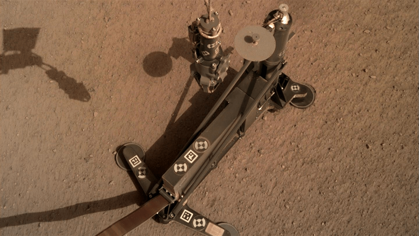
NASA’s InSight lander is busy deploying its Heat Flow and Physical Properties Package (HP3) into the Martian soil and has encountered some resistance. The German Aerospace Center (DLR), who designed and built the HP3 as part of the InSight mission, has announced that the instrument has hit not one, but two rocks in the sub-surface. For now the HP3 is in a resting phase, and it’s not clear what will happen next.

The HP3 is designed to measure the heat coming from Mars’ interior and to tell us something about the source of that heat. The basic idea is to determine how Mars formed, and if it formed the same way Earth did. It’ll also tell us something about how rocky planets in general form and evolve. But to do that, it has to get underground.

The HP3 uses a hammer system to pound itself into the ground. It works in phases, spending about four hours at a time hammering into the surface. But all that hammering creates a lot of friction and heat, so the HP3 rests for a couple days while things cool down. Then it measures the heat before continuing the cycle.

February 28th, 2019

First Evidence of Planet-Wide Groundwater System On Mars

Evolution of water-filled basins over time

Mars Express has revealed the first geological evidence of a system of ancient interconnected lakes that once lay deep beneath the Red Planet’s surface, five of which may contain minerals crucial to life.

Mars appears to be an arid world, but its surface shows compelling signs that large amounts of water once existed across the planet. We see features that would have needed water to form – branching flow channels and valleys, for example – and just last year Mars Express detected a pool of liquid water beneath the planet’s south pole.

A new study now reveals the extent of underground water on ancient Mars that was previously only predicted by models.

“Early Mars was a watery world, but as the planet’s climate changed this water retreated below the surface to form pools and ‘groundwater’,” says lead author Francesco Salese of Utrecht University, the Netherlands.

“We traced this water in our study, as its scale and role is a matter of debate, and we found the first geological evidence of a planet-wide groundwater system on Mars.”

February 22nd, 2019

With the best air pressure sensor ever on Mars, scientists find a mystery

Martian hourly weather data for Saturday, Sunday, and Monday. Note the kinks in the air pressure curve at 07:00 and 19:00 daily.

There’s a new meteorologist on Mars. Although NASA’s InSight spacecraft landed on the red planet late in 2018 to measure the planet’s geology—primarily by listening for Mars quakes—it also brought some sophisticated meteorology equipment with it.

The space agency has set up a website to share that information, which includes not only daily high and low temperatures but also unprecedented hourly data on wind speed, direction, and air pressure for InSight’s location near the equator in Elysium Planitia. “We thought it was something that people might have some fun with,” Cornell University’s Don Banfield, who leads InSight’s weather science, told Ars.

Other spacecraft have brought comparable temperature and wind sensors to Mars before, but none have carried such a precise air pressure sensor. The new sensor is 10 times more sensitive than any previous instrument because InSight needs to detect slight movements in the Martian ground, and from such movements infer details about the red planet’s interior. For this, weather matters.

The Martian atmosphere may be very thin—typically it varies between 700 and 740 pascals at the surface, less than one percent of Earth’s surface pressure—but it nonetheless can induce slight tilts in the Martian surface. The air pressure sensor will therefore help scientists calibrate the lander’s seismometer so that any tilting due to higher or lower air pressure can be filtered out of the data. It’s actually pretty amazing that even so thin an atmosphere can have a slight effect on the Martian surface and that InSight’s seismometer is sensitive enough to detect it.

January 31st, 2019

‘Mars Buggy’ Curiosity Measures a Mountain’s Gravity

Side-by-side images depict NASA’s Curiosity rover (illustration at left) and a moon buggy driven during the Apollo 16 mission. Credit: NASA/JPL-Caltech

Apollo 17 astronauts drove a moon buggy across the lunar surface in 1972, measuring gravity with a special instrument. There are no astronauts on Mars, but a group of clever researchers realized they havejust the tools for similar experiments with the Martian buggy they’re operating.

In a new paper in Science, the researchers detail how they repurposed sensors used to drive the Curiosity rover and turned them into gravimeters, which measure changes in gravitational pull. That enabled them to measure the subtle tug from rock layers on lower Mount Sharp, which rises 3 miles (5 kilometers) from the base of Gale Crater and which Curiosity has been climbing since 2014. The results? It turns out the density of those rock layers is much lower than expected.

Just like a smartphone, Curiosity carries accelerometers and gyroscopes. Moving your smartphone allows these sensors to determine its location and which way it’s facing. Curiosity’s sensors do the same thing but with far more precision, playing a crucial role in navigating the Martian surface on each drive. Knowing the rover’s orientation also lets engineers accurately point its instruments and multidirectional, high-gain antenna.

By happy coincidence, the rover’s accelerometers can be used like Apollo 17’s gravimeter. The accelerometers detect the gravity of the planet whenever the rover stands still. Using engineering data from the first five years of the mission, the paper’s authors measured the gravitational tug of Mars on the rover. As Curiosity ascends Mount Sharp, the mountain adds additional gravity – but not as much as scientists expected.

“The lower levels of Mount Sharp are surprisingly porous,” said lead author Kevin Lewis of Johns Hopkins University. “We know the bottom layers of the mountain were buried over time. That compacts them, making them denser. But this finding suggests they weren’t buried by as much material as we thought.”

January 30th, 2019

Terra Mars – Artificial Neural Network’s (ANN) topography of Mars in the visual style of Earth

Rendering of the western hemisphere of Terra Mars generation 65
2019. Centered at the enormous canyon system Valles Marineris, also featuring some or Mars’ tallest mountains, including Olympus Mons—the tallest mountain in the solar system—on the west coast.

Created by SHI Weili, For this project, Terra Mars is a speculative visualisation by an ANN (artificial neural network) to generate images that resemble satellite imagery of Earth modelled on topographical data of Mars. Terra Mars suggests a new approach to creative applications of artificial intelligence—using its capability of remapping to broaden the domain of artistic imagination.

SHI welcomes different interpretations of Terra Mars. It can be enjoyed simply as a playful remix of the two planets, or one can relate this imaginary version to the astronomical facts. Maybe one can even consider this as a preview of a possible outcome of human’s terraforming efforts, or you just appreciate the sheer beauty of a planet that resembles our own.

January 29th, 2019

The 2018 Mars Apparition

Our changing view of Mars over 2018, increasing in size as Earth got closer, than shrinking as we pulled away. Credit: Damian Peach

“Apparition” is the term astronomers use for the appearance of an object over some course of time. For Mars, it means when it first appears west of the Sun in the morning sky, after being lost in the glow. Earth moves faster in its orbit, so we catch up to Mars and pass it. When we’re closest to Mars and it’s opposite the Sun in the sky we say it’s at opposition. Mars rises at sunset and becomes an evening object. After that the Earth pulls ahead, Mars recedes, and some months later approaches the Sun from the east until it’s lost in the Sun’s glare once again, this time at dusk.

January 16th, 2019

Scientists Discover Clean Water Ice Just Below Mars’ Surface

Erosion on Mars has uncovered large, steep cross-sections of clean, subterranean ice. In this false color image captured by NASA’s HiRISE camera, one of eight recently discovered stripes appears dark blue against the Martian terrain.NASA/JPL/UNIVERSITY OF ARIZONA/USGS

Locked away beneath the surface of Mars are vast quantities of water ice. But the properties of that ice—how pure it is, how deep it goes, what shape it takes—remain a mystery to planetary geologists. Those things matter to mission planners, too: Future visitors to Mars, be they short-term sojourners or long-term settlers, will need to understand the planet’s subsurface ice reserves if they want to mine it for drinking, growing crops, or converting into hydrogen for fuel.

Trouble is, dirt, rocks, and other surface-level contaminants make it hard to study the stuff. Mars landers can dig or drill into the first few centimeters of the planet’s surface, and radar can give researchers a sense of what lies tens-of-meters below the surface. But the ice content of the geology in between—the first 20 meters or so—is largely uncharacterized.

Fortunately, land erodes. Forget radar and drilling robots: Locate a spot of land laid bare by time, and you have a direct line of sight on Mars’ subterranean layers—and any ice deposited there.

Now, scientists have discovered such a site. In fact, with the help of HiRISE, a powerful camera aboard NASA’s Mars Reconnaissance Orbiter, they’ve found several.

December 21st, 2018

Mars Express gets festive: A winter wonderland on Mars

Perspective view of Korolev crater. ESA/DLR/FU Berlin

This image shows what appears to be a large patch of fresh, untrodden snow – a dream for any lover of the holiday season. However, it’s a little too distant for a last-minute winter getaway: this feature, known as Korolev crater, is found on Mars, and is shown here in beautiful detail as seen by Mars Express.

ESA’s Mars Express mission launched on 2 June 2003, and reached Mars six months later. The satellite fired its main engine and entered orbit around the Red Planet on 25 December, making this month the 15-year anniversary of the spacecraft’s orbit insertion and the beginning of its science programme.

These images are an excellent celebration of such a milestone. Taken by the Mars Express High Resolution Stereo Camera (HRSC), this view of Korolev crater comprises five different ‘strips’ that have been combined to form a single image, with each strip gathered over a different orbit. The crater is also shown in perspective, context, and topographic views, all of which offer a more complete view of the terrain in and around the crater.

December 4th, 2018

NASA InSight Lander’s New Home on Mars ‘a Large Sandbox’

NASA’s InSight spacecraft flipped open the lens cover on its Instrument Context Camera (ICC) on Nov. 30, 2018, and captured this view of Mars. Located below the deck of the InSight lander, the ICC has a fisheye view, creating a curved horizon. Some clumps of dust are still visible on the camera’s lens. One of the spacecraft’s footpads can be seen in the lower right corner. The seismometer’s tether box is in the upper left corner. Image credit: NASA/JPL-Caltech

With InSight safely on the surface of Mars, the mission team at NASA’s Jet Propulsion Laboratory in Pasadena, California, is busy learning more about the spacecraft’s landing site. They knew when InSight landed on Nov. 26 that the spacecraft had touched down on target, a lava plain named Elysium Planitia. Now they’ve determined that the vehicle sits slightly tilted (about 4 degrees) in a shallow dust- and sand-filled impact crater known as a “hollow.” InSight has been engineered to operate on a surface with an inclination up to 15 degrees.

“The science team had been hoping to land in a sandy area with few rocks since we chose the landing site, so we couldn’t be happier,” said InSight project manager Tom Hoffman of JPL. “There are no landing pads or runways on Mars, so coming down in an area that is basically a large sandbox without any large rocks should make instrument deployment easier and provide a great place for our mole to start burrowing.”

Rockiness and slope grade factor into landing safety and are also important in determining whether InSight can succeed in its mission after landing. Rocks and slopes could affect InSight’s ability to place its heat-flow probe – also known as “the mole,” or HP3 – and ultra-sensitive seismometer, known as SEIS, on the surface of Mars.

November 29th, 2018

Opinion: Mars Beckons

Niv Bavarsky

The science and technology behind NASA’s latest space explorer to land on Mars are so awe-inducing that it’s hardly surprising when scientists commenting on the triumph drop their usual jargon to speak like excited schoolchildren.

“It’s nice and dirty; I like that,” was how Bruce Banerdt, the principal investigator behind the InSight mission, reacted when, shortly after setting down Monday on the flat and featureless Martian plain known as the Elysium Planitia, the lander beamed back an image speckled with red dust. “This image is actually a really good argument for why you put a dust cover on a camera. Good choice, right?”

Unlike the [rovers], InSight — Interior Exploration using Seismic Investigations, Geodesy and Heat Transport — is meant to stay in one spot and deploy instruments to measure marsquakes (yes, on Earth they’re “earthquakes”) in order to learn about what’s going on in the innards of the planet. One gizmo will take Mars’s temperature by hammering itself 16 feet below the surface. Deploying the instruments alone is expected to take two months, and the entire mission is meant to last a Martian year, roughly two Earth years.

What for? A random sampling of comments from the public suggests not everyone is convinced that digging on Mars is money well spent. But the basic answer is that whether it’s practical or not, humans will continue to explore the heavens so long as the moon, Mars and the myriad celestial bodies beyond fire our imagination and curiosity. What happened in the earliest days of the universe? How were Earth and its fellow planets formed? And the question of questions: Is there life out there?

Buy Shrooms Online Best Magic Mushroom Gummies
Best Amanita Muscaria Gummies