MarsNews.com
November 8th, 2016

Capturing Martian Weather in Motion

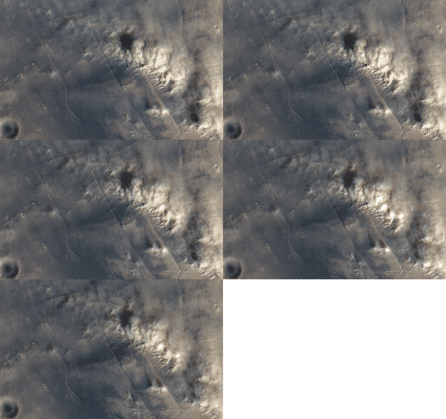
Dust stom over Tempe Terra, Mars ESA / DLR / FU Berlin (G. Neukum) / Justin Cowart

Dust stom over Tempe Terra, Mars
ESA / DLR / FU Berlin (G. Neukum) / Justin Cowart

Still images of Mars often give us a false impression that Mars is a dead planet, with nothing going on other than the occasional dust storm. Do a quick image search for Mars and most of the results are mosaics designed to show Martian geography, not meteorology. But these images don’t tell the planet’s full story. Martian weather is dynamic, with water ice cloud streets forming around the polar areas, cold fronts pushing through the midlatitudes and raising dust storms, and thin hazes forming as air flows around topographic obstacles like volcanoes and crater rims.

No space agency has deployed a dedicated weather satellite to Mars, so we can’t watch these systems form and move across the surface like we can with the spectacular images of Earth returned by satellites like Himawari-8. In fact, the only instrument dedicated to monitoring Martian weather, the Mars Color Imager (MARCI) onboard the Mars Reconnaissance Orbiter, can only image a location on the Martian surface once per day (with the exception of some areas near the poles).

Fortunately for Martian weather enthusiasts, there is a way to get a glimpse of weather in action at the Martian surface. The High Resolution Stereo Colour Imager (HRSC) instrument onboard Mars Express was designed to produce stereographic color maps of Mars. To do this, HRSC uses a set of 9 pushbroom sensors. Four of these sensors image the surface in color at blue, green, red, and near-IR wavelengths. The other five collect stereo and photometric data using broadband filters that cover the same roughly the same spectral range. The sensors are mounted at different angles, looking between 20 degrees ahead and behind the spacecraft. Parallax from the five different viewing angles allows mission scientists to create DEMs of the surface with 10 to 15 meter vertical resolution.

That’s the intended purpose, anyway. The offset viewing angles for the sensors onboard the spacecraft allow for something else: time-lapse images. The imaging setup means that the first imaging channel sees the surface about 70 seconds before the last. If the wind is blowing at the surface, the time between sequential images is just long enough that the motion of dust clouds is visible. If clouds are at higher altitude, then the parallax also shows up as motion. The color data can then be overlain to colorize the scene.

November 3rd, 2016

Egg Rock: Lessons from the iron meteorite Curiosity found on Mars

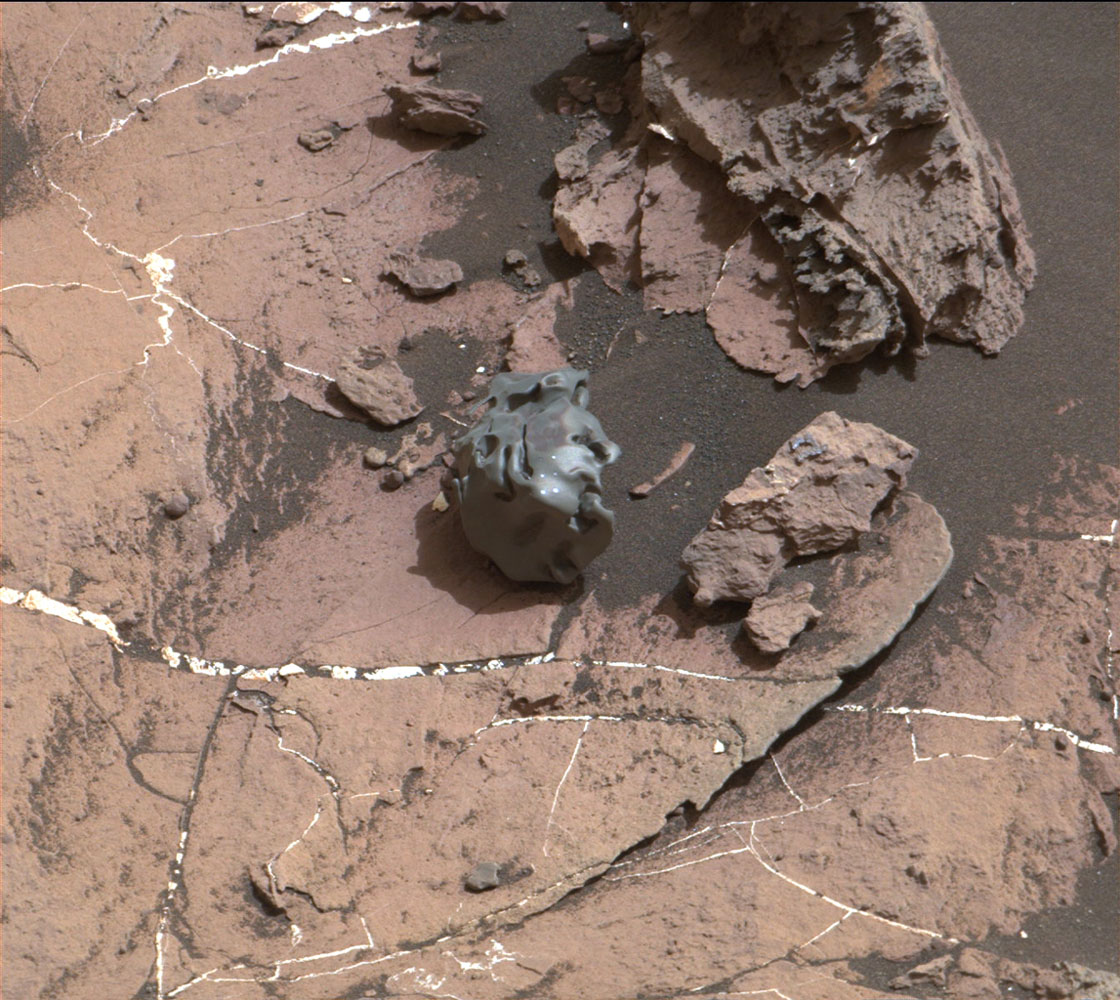
The dark, smooth-surfaced rock at the center of this Oct. 30, 2016, image from the Mast Camera (Mastcam) on NASA's Curiosity Mars rover was examined with laser pulses and confirmed to be an iron-nickel meteorite. It is about the size of a golf ball. Credit: NASA/JPL-Caltech/MSSS

The dark, smooth-surfaced rock at the center of this Oct. 30, 2016, image from the Mast Camera (Mastcam) on NASA’s Curiosity Mars rover was examined with laser pulses and confirmed to be an iron-nickel meteorite. It is about the size of a golf ball. Credit: NASA/JPL-Caltech/MSSS

It’s been more than four years since NASA’s Curiosity rover landed on Mars, enabling researchers to study the shape and composition of the planet’s landscape in a mission that had originally been planned to last less than two years. Even as the rover’s instruments begin to show signs of wear and tear, however, scientists are still making discoveries.

For the first time on Mars, researchers used a spectrometer to zap an object the size of a golfball with a laser this week to confirm that it is an iron-nickel meteorite that fell to the planet’s surface, according to NASA and the Jet Propulsion Laboratory. Although such objects are common on Earth and to be expected on the Red Planet as well, studying them in tandem with what we already know about the planet’s atmosphere could reveal a wealth of new information about the history of the solar system.

Horton Newsom, a researcher from the University of New Mexico, Albuquerque, said the object, known as Egg Rock, could carry within its core information that differs from asteroids currently being studied.

October 18th, 2016

MAVEN Gives Unprecedented Ultraviolet View of Mars

New global images of Mars from the MAVEN mission show the ultraviolet glow from the Martian atmosphere in unprecedented detail, revealing dynamic, previously invisible behavior. They include the first images of “nightglow” that can be used to show how winds circulate at high altitudes. Additionally, dayside ultraviolet imagery from the spacecraft shows how ozone amounts change over the seasons and how afternoon clouds form over giant Martian volcanoes. The images were taken by the MAVEN Imaging UltraViolet Spectrograph (IUVS).

“MAVEN obtained hundreds of such images in recent months, giving some of the best high-resolution ultraviolet coverage of Mars ever obtained,” said Nick Schneider of the Laboratory for Atmospheric and Space Physics at the University of Colorado Boulder. Schneider is presenting these results Oct. 19 at the American Astronomical Society Division for Planetary Sciences meeting in Pasadena, California.

September 16th, 2016

Mars had liquid water a billion years longer than we even thought possible

Valleys much younger than well-known ancient valley networks on Mars are evident near the informally named “Heart Lake” on Mars. This map presents color-coded topographical information overlaid onto a photo mosaic. Lower elevations are indicated with white and purple; higher elevations, yellow.
Credits: NASA/JPL-Caltech/ASU

Lakes and snowmelt-fed streams on Mars formed much later than previously thought possible, according to new findings using data primarily from NASA’s Mars Reconnaissance Orbiter.

The recently discovered lakes and streams appeared roughly a billion years after a well-documented, earlier era of wet conditions on ancient Mars. These results provide insight into the climate history of the Red Planet and suggest the surface conditions at this later time may also have been suitable for microbial life.

“We discovered valleys that carried water into lake basins,” said Sharon Wilson of the Smithsonian Institution, Washington, and the University of Virginia, Charlottesville. “Several lake basins filled and overflowed, indicating there was a considerable amount of water on the landscape during this time.”

Wilson and colleagues found evidence of these features in Mars’ northern Arabia Terra region by analyzing images from the Context Camera and High Resolution Imaging Science Experiment camera on the Mars Reconnaissance Orbiter and additional data from NASA’s Mars Global Surveyor and the European Space Agency’s Mars Express.

September 13th, 2016

Mars Rover Views Spectacular Layered Rock Formations

This view from the Mast Camera (Mastcam) on NASA’s Curiosity Mars rover shows a hillside outcrop with layered rocks within the “Murray Buttes” region on lower Mount Sharp.

The layered geologic past of Mars is revealed in stunning detail in new color images returned by NASA’s Curiosity Mars rover, which is currently exploring the “Murray Buttes” region of lower Mount Sharp. The new images arguably rival photos taken in U.S. National Parks.

Curiosity took the images with its Mast Camera (Mastcam) on Sept. 8. The rover team plans to assemble several large, color mosaics from the multitude of images taken at this location in the near future.

“Curiosity’s science team has been just thrilled to go on this road trip through a bit of the American desert Southwest on Mars,” said Curiosity Project Scientist Ashwin Vasavada, of NASA’s Jet Propulsion Laboratory, Pasadena, California.

August 17th, 2016

Gullies on Mars: Wet or Dry (Ice)?

Martian gullies were in the spotlight recently thanks to a NASA press release stating they were “likely not formed by liquid water.” The release concerns the publication of a new paper by Nuñez et al. in Geophysical Research Letters, which looked at spectral data of gullies from the Mars Reconnaissance Orbiter (MRO) Compact Reconnaissance Imaging Spectrometer for Mars (CRISM).

In their study, Nuñez and his colleagues looked at over 100 gullied locations on Mars. They found no evidence of minerals that would be expected to form in the presence of water. Rather than water, they point to sublimation of seasonal carbon dioxide frost as the main culprit behind gully formation on Mars. Other people have proposed a similar model to explain present-day activity in gullies, which appears to happen during periods of active defrosting. But this process has been a topic of debate among the Mars gullies community, and was a big discussion point at the “Martian Gullies and Their Earth Analogues” workshop in London back in June. Can this dry process explain both the initial formation of gullies and gullies’ modern-day activity?

May 15th, 2016

The seasons on Mars: NASA’s Curiosity rover paints a picture

NASA’s Curiosity rover completed its second Martian year – 687 Earth days – on May 11, meaning that its instruments have now tasted the red planet’s tendencies for two full orbits of the sun.

This allows scientists to begin separating unique events from those that recur year by year, laying the foundation for an understanding of seasonal variations in a host of different characteristics.

The fresh insights come at a time when talk of a manned mission to Mars is edging away from the arena of science fiction and towards the realm of human endeavor.

March 24th, 2016

NASA gravity map offers closest ever look at Mars

By tracking the gravitational pull on spacecraft over Mars, NASA has created one of the most detailed maps yet of the Red Planet’s surface, and what lies beneath.

“Gravity maps allow us to see inside a planet, just as a doctor uses an X-ray to see inside a patient,” Antonio Genova of the Massachusetts Institute of Technology (MIT) said in a statement.
“The new gravity map will be helpful for future Mars exploration, because better knowledge of the planet’s gravity anomalies helps mission controllers insert spacecraft more precisely into orbit about Mars.”
As well as providing insight for future missions, the gravity map also offers explanations for developments in the planet’s past.

March 10th, 2016

Close comet flyby threw Mars’ magnetic field into chaos

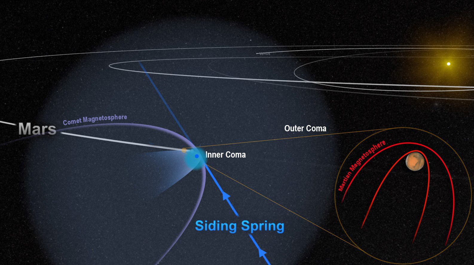
The close encounter between comet Siding Spring and Mars flooded the planet with an invisible tide of charged particles from the comet’s coma. The dense inner coma reached the surface of the planet, or nearly so. The comet’s powerful magnetic field temporarily merged with, and overwhelmed, the planet’s weak field, as shown in this artist’s depiction. Illustration credits: NASA/Goddard.

Just weeks before the historic encounter of comet C/2013 A1 (Siding Spring) with Mars in October 2014, NASA’s Mars Atmosphere and Volatile Evolution (MAVEN) spacecraft entered orbit around the Red Planet. To protect sensitive equipment aboard MAVEN from possible harm, some instruments were turned off during the flyby; the same was done for other Mars orbiters. But a few instruments, including MAVEN’s magnetometer, remained on, conducting observations from a front-row seat during the comet’s remarkably close flyby.
The one-of-a-kind opportunity gave scientists an intimate view of the havoc that the comet’s passing wreaked on the magnetic environment, or magnetosphere, around Mars. The effect was temporary but profound.

“Comet Siding Spring plunged the magnetic field around Mars into chaos,” said Jared Espley, a MAVEN science team member at NASA’s Goddard Space Flight Center in Greenbelt, Maryland. “We think the encounter blew away part of Mars’ upper atmosphere, much like a strong solar storm would.”

November 27th, 2015

The Amazingly Creepy Way Mars Will Kill One of Its Moons

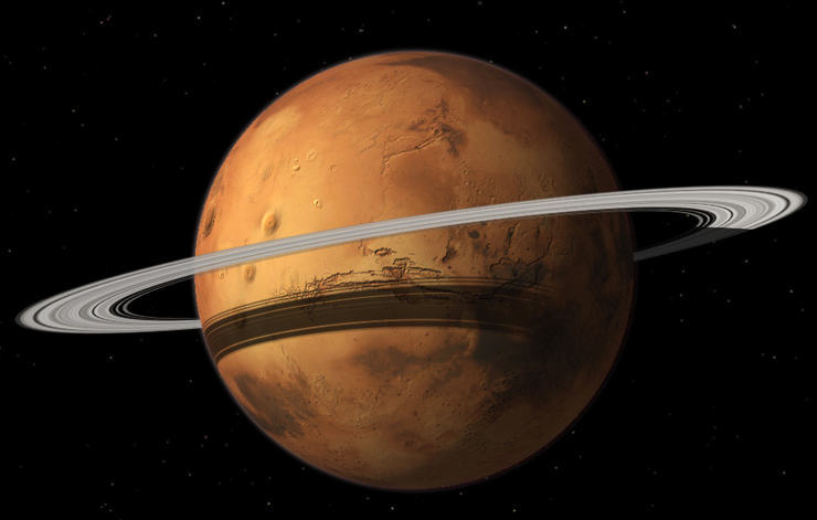
It was a rough month for Phobos, as astronomers decreed—yet again—that Mars is ripping its lumpy moon apart. But apparently, Phobos’ loss is the Red Planet’s gain. After the satellite is torn to pieces, its fragments will fan out into a disk and 20 million years from now, Mars will become a ringed planet.

That’s the conclusion of a UC Berkeley-led study published this week in Nature Geoscience, which takes Phobos’ violent demise to an unexpectedly beautiful conclusion. But this little moon’s fate is more than just a cosmic curiosity. Rather, the researchers argue that Phobos could be a window into the origin of ring systems throughout the Solar System and beyond.

Buy Shrooms Online Best Magic Mushroom Gummies
Best Amanita Muscaria Gummies