MarsNews.com
January 31st, 2017

Love Science? Mars Needs You

NASA/JPL/University of Arizona

NASA/JPL/University of Arizona

Mars has some impressive geological features across its cold, desiccated surface, many of which are similar to featured found here on Earth. By studying them, scientists are able to learn more about the natural history of the Red Planet, what kinds of meteorological phenomena are responsible for shaping it, and how similar our two planets are. A perfect of example of this are the polygon-ridge networks that have been observed on its surface.

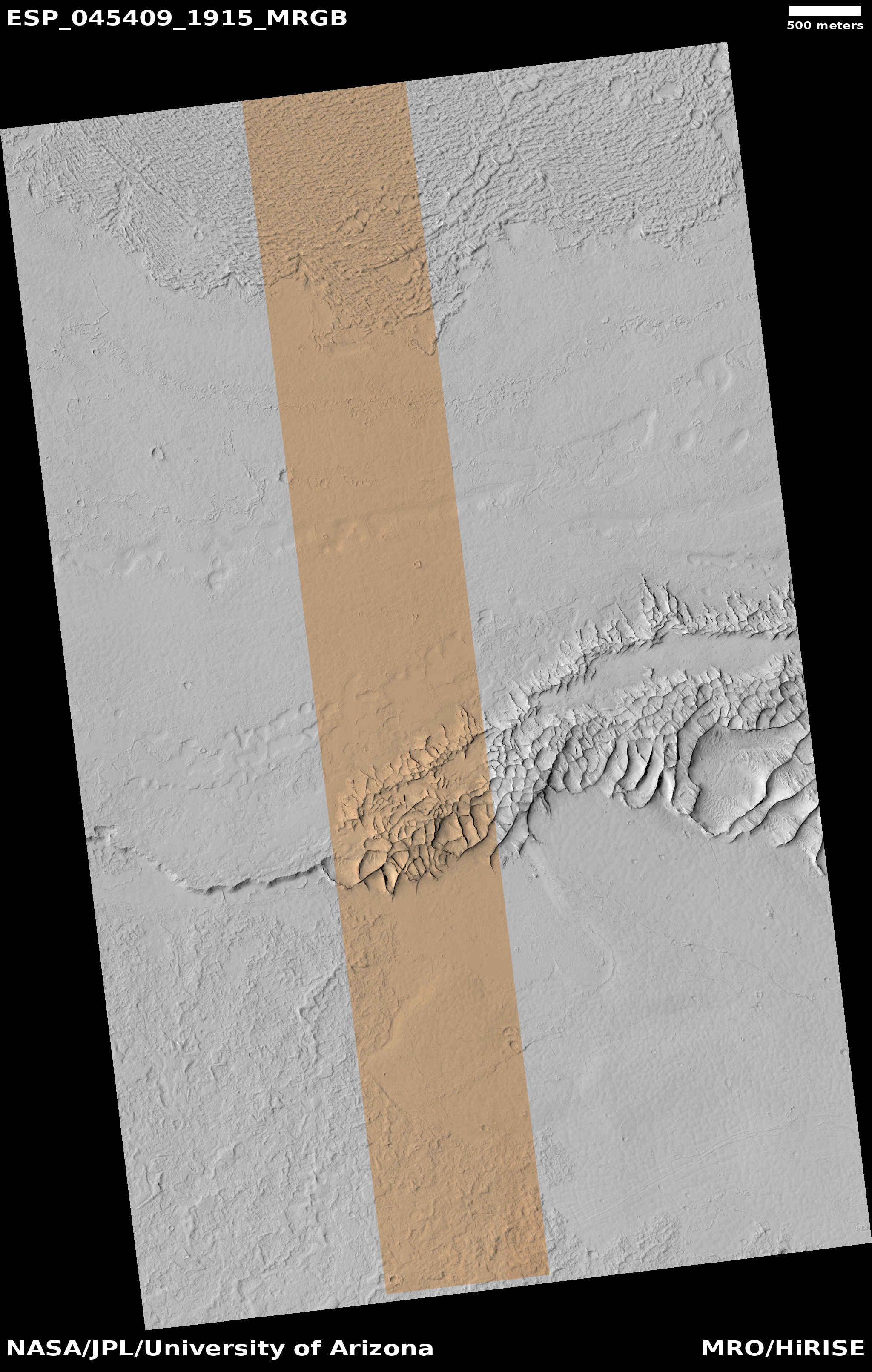
One such network was recently discovered by the Mars Reconnaissance Orbiter (MRO) in the Medusae Fossae region, which straddles the planet’s equator. Measuring some 16 story’s high, this ridge network is similar to others that have been spotted on Mars. But according to a survey produced by researchers from NASA’s Jet Propulsion Laboratory, these ridges likely have different origins.

This survey, which was recently published in the journal Icarus, examined both the network found in the Medusae Fossae region and similar-looking networks in other regions of the Red Planet. These ridges (sometimes called boxwork rides), are essentially blade-like walls that look like multiple adjoining polygons (i.e. rectangles, pentagons, triangles, and similar shapes).

January 6th, 2017

New image shows Earth and Moon from Mars orbiter

Photo by NASA/JPL-Caltech/Univ. of Arizona

Photo by NASA/JPL-Caltech/Univ. of Arizona

There’s a lot of talk in our modern space race about getting to Mars, so every once in a while it’s nice to see what we’d be leaving behind if we did eventually make it to the Red Planet.

Thankfully, images from the High Resolution Imaging Science Experiment (HiRISE) camera on NASA’s Mars Reconnaissance Orbiter can help us out with that. A new composite image released on Friday shows off Earth and its moon, taken when Mars was about 127 million miles away on Nov. 20.

The photograph is constructed from the best shot of Earth and the best shot of the moon from four sets of images, according to a post by Alfred McEwen, a planetary scientist at the University of Arizona who is the principal investigator for the HiRISE camera on Mars Reconnaissance Orbiter.

November 22nd, 2016

Widespread, Thick Water Ice found in Utopia Planitia, Mars

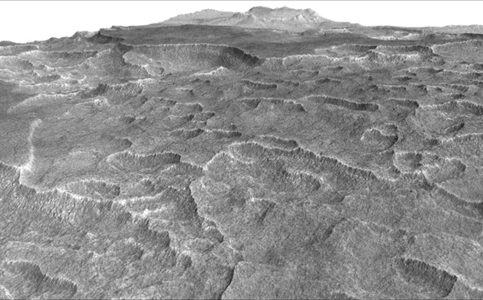
This vertically exaggerated view shows scalloped depressions in a part of Mars where such textures prompted researchers to check for buried ice, using ground-penetrating radar aboard NASA's Mars Reconnaissance Orbiter. Image Credit: NASA/JPL-Caltech/Univ. of Arizona

This vertically exaggerated view shows scalloped depressions in a part of Mars where such textures prompted researchers to check for buried ice, using ground-penetrating radar aboard NASA’s Mars Reconnaissance Orbiter. Image Credit: NASA/JPL-Caltech/Univ. of Arizona

My paper on the discovery of a widespread (~375 000 sq km) subsurface water ice deposit in southwestern Utopia Planitia, Mars, was published in Geophysical Research Letters (GRL) a few weeks back, along with a NASA press release today. The detailed version is offered in the journal article, but I thought I’d include a higher-level description of what’s up in here.

When you look at Utopia Planitia, there’s a lot of weird stuff going on. For those that aren’t intimately familiar with martian geography, Utopia Planitia is a huge, ~3300 km diameter basin that formed by impact early in Mars’ history. It makes up part of what’s known as the northern plains, the more-or-less flat terrain north of the martian dichotomy boundary. For as long as we’ve had good imagery from the region, we’ve noticed interesting features on the surface—features like polygonal cracked terrain and oddly-shaped, rimless pits called “scalloped depressions”. When we see features like this on Earth, they’re associated with subsurface ice or permafrost. These features led scientists to believe that this is an ice-rich region of Mars, and inspired my team to examine radar sounding data from the area.

October 27th, 2016

Closer Look at Schiaparelli Impact Site on Mars

Image credit: NASA/JPL-Caltech/Univ. of Arizona

Image credit: NASA/JPL-Caltech/Univ. of Arizona

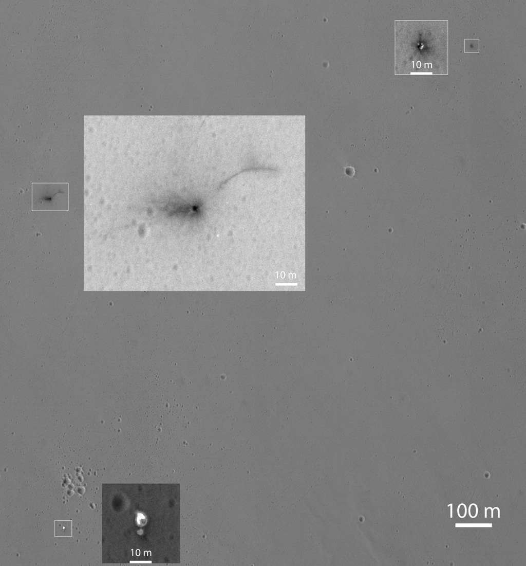
This Oct. 25, 2016, image shows the area where the European Space Agency’s Schiaparelli test lander reached the surface of Mars, with magnified insets of three sites where components of the spacecraft hit the ground. It is the first view of the site from the High Resolution Imaging Science Experiment (HiRISE) camera on NASA’s Mars Reconnaissance Orbiter taken after the Oct. 19, 2016, landing event.

The Schiaparelli test lander was one component of ESA’s ExoMars 2016 project, which placed the Trace Gas Orbiter into orbit around Mars on the same arrival date.

This HiRISE observation adds information to what was learned from observation of the same area on Oct. 20 by the Mars Reconnaissance Orbiter’s Context Camera (CTX). Of these two cameras, CTX covers more area and HiRISE shows more detail. A portion of the HiRISE field of view also provides color information. The impact scene was not within that portion for the Oct. 25 observation, but an observation with different pointing to add color and stereo information is planned.

This Oct. 25 observation shows three locations where hardware reached the ground, all within about 0.9 mile (1.5 kilometer) of each other, as expected. The annotated version includes insets with six-fold enlargement of each of those three areas. Brightness is adjusted separately for each inset to best show the details of that part of the scene. North is about 7 degrees counterclockwise from straight up. The scale bars are in meters.

October 21st, 2016

Mars Reconnaissance Orbiter views Schiaparelli landing site

NASA’s Mars Reconnaissance Orbiter has identified new markings on the surface of the Red Planet that are believed to be related to ESA’s ExoMars Schiaparelli entry, descent and landing technology demonstrator module.

Schiaparelli entered the martian atmosphere at 14:42 GMT on 19 October for its 6-minute descent to the surface, but contact was lost shortly before expected touchdown. Data recorded by its mothership, the Trace Gas Orbiter, are currently being analysed to understand what happened during the descent sequence.

In the meantime, the low-resolution CTX camera on-board the Mars Reconnaissance Orbiter (MRO) took pictures of the expected touchdown site in Meridiani Planum on 20 October as part of a planned imaging campaign.

Estimates are that Schiaparelli dropped from a height of between 2 and 4 kilometres, therefore impacting at a considerable speed, greater than 300 km/h. The relatively large size of the feature would then arise from disturbed surface material. It is also possible that the lander exploded on impact, as its thruster propellant tanks were likely still full. These preliminary interpretations will be refined following further analysis.

September 16th, 2016

Mars had liquid water a billion years longer than we even thought possible

Valleys much younger than well-known ancient valley networks on Mars are evident near the informally named “Heart Lake” on Mars. This map presents color-coded topographical information overlaid onto a photo mosaic. Lower elevations are indicated with white and purple; higher elevations, yellow.
Credits: NASA/JPL-Caltech/ASU

Lakes and snowmelt-fed streams on Mars formed much later than previously thought possible, according to new findings using data primarily from NASA’s Mars Reconnaissance Orbiter.

The recently discovered lakes and streams appeared roughly a billion years after a well-documented, earlier era of wet conditions on ancient Mars. These results provide insight into the climate history of the Red Planet and suggest the surface conditions at this later time may also have been suitable for microbial life.

“We discovered valleys that carried water into lake basins,” said Sharon Wilson of the Smithsonian Institution, Washington, and the University of Virginia, Charlottesville. “Several lake basins filled and overflowed, indicating there was a considerable amount of water on the landscape during this time.”

Wilson and colleagues found evidence of these features in Mars’ northern Arabia Terra region by analyzing images from the Context Camera and High Resolution Imaging Science Experiment camera on the Mars Reconnaissance Orbiter and additional data from NASA’s Mars Global Surveyor and the European Space Agency’s Mars Express.

August 17th, 2016

Gullies on Mars: Wet or Dry (Ice)?

Martian gullies were in the spotlight recently thanks to a NASA press release stating they were “likely not formed by liquid water.” The release concerns the publication of a new paper by Nuñez et al. in Geophysical Research Letters, which looked at spectral data of gullies from the Mars Reconnaissance Orbiter (MRO) Compact Reconnaissance Imaging Spectrometer for Mars (CRISM).

In their study, Nuñez and his colleagues looked at over 100 gullied locations on Mars. They found no evidence of minerals that would be expected to form in the presence of water. Rather than water, they point to sublimation of seasonal carbon dioxide frost as the main culprit behind gully formation on Mars. Other people have proposed a similar model to explain present-day activity in gullies, which appears to happen during periods of active defrosting. But this process has been a topic of debate among the Mars gullies community, and was a big discussion point at the “Martian Gullies and Their Earth Analogues” workshop in London back in June. Can this dry process explain both the initial formation of gullies and gullies’ modern-day activity?

March 24th, 2016

NASA gravity map offers closest ever look at Mars

By tracking the gravitational pull on spacecraft over Mars, NASA has created one of the most detailed maps yet of the Red Planet’s surface, and what lies beneath.

“Gravity maps allow us to see inside a planet, just as a doctor uses an X-ray to see inside a patient,” Antonio Genova of the Massachusetts Institute of Technology (MIT) said in a statement.
“The new gravity map will be helpful for future Mars exploration, because better knowledge of the planet’s gravity anomalies helps mission controllers insert spacecraft more precisely into orbit about Mars.”
As well as providing insight for future missions, the gravity map also offers explanations for developments in the planet’s past.

March 16th, 2016

Ten Years of Discovery by Mars Reconnaissance Orbiter

True to its purpose, the big NASA spacecraft that began orbiting Mars a decade ago this week has delivered huge advances in knowledge about the Red Planet.

NASA’s Mars Reconnaissance Orbiter (MRO) has revealed in unprecedented detail a planet that held diverse wet environments billions of years ago and remains dynamic today.

One example of MRO’s major discoveries was published last year, about the possibility of liquid water being present seasonally on present-day Mars. It drew on three key capabilities researchers gained from this mission: telescopic camera resolution to find features narrower than a driveway; spacecraft longevity to track seasonal changes over several Martian years; and imaging spectroscopy to map surface composition.

Other discoveries have resulted from additional capabilities of the orbiter. These include identifying underground geologic structures, scanning atmospheric layers and observing the entire planet’s weather daily. All six of the orbiter’s science instruments remain productive in an extended mission more than seven years after completion of the mission’s originally planned primary science phase.

October 16th, 2015

Comet’s Close Encounter with Mars Dumped Tons of Dust on Red Planet

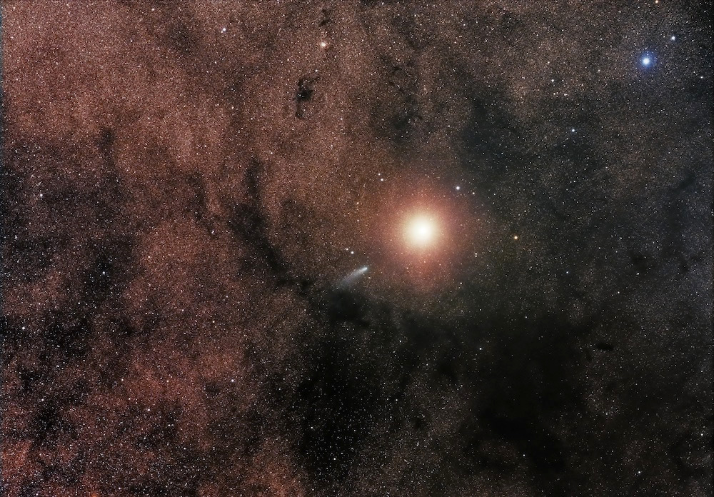
Sebastian Voltmer in Germany used the iTelescope at Siding Spring Observatory, Coonabarabran, New South Wales, Australia to capture Comet C/2013 A1 passing very close to Mars on 19 October 2014. He used their Takahashi FSQ ED refractor and SBIG STL11000M camera for four 120-seconds exposures; RGB 120-seconds (Bin 2). Image credit: © Sebastian Voltmer.


Comet Siding Spring’s close shave by Mars last year provided a rare glimpse into how Oort Cloud comets behave, according to new research.

The comet flew by Mars at a range of just 83,900 miles (135,000 kilometers) — close enough for the outer ridges of its tenuous atmosphere to pummel the planet with gas and dust.

In just a short flyby, the comet dumped about 2,200 to 4,410 lbs. (1,000 to 2,000 kg) of dust made of magnesium, silicon, calcium and potassium — all of which are rock-forming elements — into the upper atmosphere, the new study found.

Buy Shrooms Online Best Magic Mushroom Gummies
Best Amanita Muscaria Gummies