MarsNews.com
October 8th, 2015

NASA’s Curiosity Rover Team Confirms Ancient Lakes on Mars

http://www.jpl.nasa.gov/spaceimages/images/largesize/PIA19839_hires.jpg

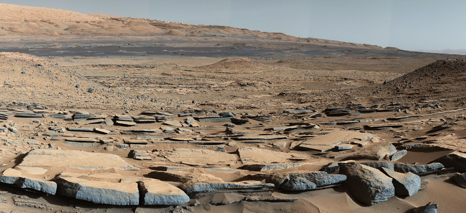
Strata at Base of Mount Sharp

A new study from the team behind NASA’s Mars Science Laboratory/Curiosity has confirmed that Mars was once, billions of years ago, capable of storing water in lakes over an extended period of time.

Using data from the Curiosity rover, the team has determined that, long ago, water helped deposit sediment into Gale Crater, where the rover landed more than three years ago. The sediment deposited as layers that formed the foundation for Mount Sharp, the mountain found in the middle of the crater today.

“Observations from the rover suggest that a series of long-lived streams and lakes existed at some point between about 3.8 to 3.3 billion years ago, delivering sediment that slowly built up the lower layers of Mount Sharp,” said Ashwin Vasavada, Mars Science Laboratory project scientist at NASA’s Jet Propulsion Laboratory in Pasadena, California, and co-author of the new Science article to be published Friday, Oct. 9.

September 28th, 2015

NASA Confirms Evidence That Liquid Water Flows on Today’s Mars NASA

9-28-2015 8-53-47 AM

mars-lineae-slopes-garni-crater-perspective6-PIA19917-br2

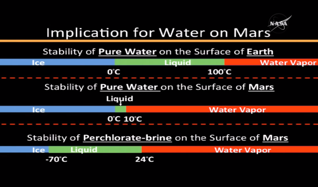
New findings from NASA’s Mars Reconnaissance Orbiter (MRO) provide the strongest evidence yet that liquid water flows intermittently on present-day Mars. Using an imaging spectrometer on MRO, researchers detected signatures of hydrated minerals on slopes where mysterious streaks are seen on the Red Planet. These darkish streaks appear to ebb and flow over time. They darken and appear to flow down steep slopes during warm seasons, and then fade in cooler seasons. They appear in several locations on Mars when temperatures are above minus 10 degrees Fahrenheit (minus 23 Celsius), and disappear at colder times.
“Our quest on Mars has been to ‘follow the water,’ in our search for life in the universe, and now we have convincing science that validates what we’ve long suspected,” said John Grunsfeld, astronaut and associate administrator of NASA’s Science Mission Directorate in Washington. “This is a significant development, as it appears to confirm that water — albeit briny — is flowing today on the surface of Mars.”

September 14th, 2015

Terraced Craters: Windows Into Mars’ Icy Past NASA

It was a “crazy-looking crater” on the face of Mars that caught Ali Bramson’s eye. But it was a simple calculation that explained the crater’s strange shape.

Combining data gleaned from two powerful instruments aboard NASA’s Mars Reconnaissance Orbiter, or MRO, Bramson and her colleagues determined why the crater is terraced — not bowl shaped, like most craters of this size.

“Craters should be bowl shaped, but this one had terraces in the wall,” says Bramson, a graduate student in the University of Arizona’s Lunar and Planetary Laboratory, or LPL.

Terraces can form when there are layers of different materials in the planet’s subsurface, such as dirt, ice or rock.

“When the crater is forming, the shock wave from an object hitting a planet’s surface propagates differently depending on what substrates are beneath the area of impact,” Bramson says. “If you have a weaker material in one layer, the shock wave can push out that material more easily, and the result is terracing at the interface between the weaker and stronger materials.”

August 20th, 2015

NASA to rely on Mars programme’s silent workhorse for years to come NASA

PIA07245_200609062-fi

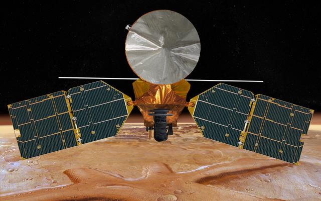
NASA’s Mars Reconnaissance Orbiter, aging and arthritic a decade after its launch, remains productive and is expected to be the primary pipeline for high-resolution maps of Mars for scientists and mission planners over the next decade.

Scientists who want to study Mars’ enigmatic history, tenuous water cycle and climate will continue to rely on the nearly $900 million MRO mission, and engineers charged with selecting landing sites for future Mars rovers, and eventual human expeditions, will use maps created from the orbiter’s imagery, officials said.

And the success of future landers, beginning with NASA’s InSight seismic probe next year, depend in part on MRO’s availability to relay data from the Martian surface to Earth.

July 28th, 2015

NASA Mars Orbiter Preparing for Mars Lander’s 2016 Arrival NASA

With its biggest orbit maneuver since 2006, NASA’s Mars Reconnaissance Orbiter (MRO) will prepare this week for the arrival of NASA’s next Mars lander, InSight, next year.

A planned 77-second firing of six intermediate-size thrusters on July 29 will adjust the orbit timing of the veteran spacecraft so it will be in position to receive radio transmissions from InSight as the newcomer descends through the Martian atmosphere and touches down on Sept. 28, 2016. These six rocket engines, which were used for trajectory corrections during the spacecraft’s flight from Earth to Mars, can each produce about 22 newtons, or five pounds, of thrust.

“Without making this orbit change maneuver, Mars Reconnaissance Orbiter would be unable to hear from InSight during the landing, but this will put us in the right place at the right time,” said MRO Project Manager Dan Johnston of NASA’s Jet Propulsion Laboratory, Pasadena, California.

July 22nd, 2015

New Website Gathering Public Input on NASA Mars Images NASA

Science-team members for NASA’s Mars Reconnaissance Orbiter are soliciting help from the public to analyze exotic features near the south pole of Mars.

By categorizing features visible in images from the orbiter’s Context Camera (CTX), volunteers are using their own computers to help the team identify specific areas for even more detailed examination with the orbiter’s High Resolution Imaging Science Experiment (HiRISE) camera. HiRISE can reveal more detail than any other camera ever put into orbit around Mars.

Information about how to participate is at the “Planet Four: Terrains” website, at:

http://www.planetfour.org

June 3rd, 2015

Mars Missions to Pause Commanding in June, Due to Sun NASA

In June 2015, Mars will swing almost directly behind the sun from Earth’s perspective, and this celestial geometry will lead to diminished communications with spacecraft at Mars.

The arrangement of the sun between Earth and Mars is called Mars solar conjunction. It occurs about every 26 months as the two planets travel in their sun-centered orbits. The sun disrupts radio communications between the planets during the conjunction period. To prevent spacecraft at Mars from receiving garbled commands that could be misinterpreted or even harmful, the operators of Mars orbiters and rovers temporarily stop sending any commands.

May 4th, 2015

Traffic Around Mars Gets Busy NASA

NASA has beefed up a process of traffic monitoring, communication and maneuver planning to ensure that Mars orbiters do not approach each other too closely.

Last year’s addition of two new spacecraft orbiting Mars brought the census of active Mars orbiters to five, the most ever. NASA’s Mars Atmosphere and Volatile Evolution (MAVEN) and India’s Mars Orbiter Mission joined the 2003 Mars Express from ESA (the European Space Agency) and two from NASA: the 2001 Mars Odyssey and the 2006 Mars Reconnaissance Orbiter (MRO). The newly enhanced collision-avoidance process also tracks the approximate location of NASA’s Mars Global Surveyor, a 1997 orbiter that is no longer working.

It’s not just the total number that matters, but also the types of orbits missions use for achieving their science goals. MAVEN, which reached Mars on Sept. 21, 2014, studies the upper atmosphere. It flies an elongated orbit, sometimes farther from Mars than NASA’s other orbiters and sometimes closer to Mars, so it crosses altitudes occupied by those orbiters. For safety, NASA also monitors positions of ESA’s and India’s orbiters, which both fly elongated orbits

April 23rd, 2015

Mars Orbiter Views Curiosity Rover in ‘Artist’s Drive’ NASA

A view from NASA’s Mars Reconnaissance Orbiter on April 8, 2015, catches sight of NASA’s Curiosity Mars rover passing through a valley called “Artist’s Drive” on the lower slope of Mount Sharp.

The image from the orbiter’s High Resolution Imaging Science Experiment (HiRISE) camera shows the rover’s position after a drive of about 75 feet (23 meters) during the 949th Martian day, or sol, of the rover’s work on Mars.

The location of the rover, with its shadow extending toward the right, is indicated with an inscribed rectangle. North is toward the top. The view covers an area about 550 yards (500 meters) across.

April 14th, 2015

Mars has belts of glaciers consisting of frozen water Astronomy Magazine

Mars has distinct polar ice caps, but the Red Planet also has belts of glaciers at its central latitudes in both the southern and northern hemispheres. A thick layer of dust covers the glaciers, so they appear as surface of the ground, but radar measurements show that underneath the dust there are glaciers composed of frozen water. New studies have now calculated the size of the glaciers and thus the amount of water in the glaciers. It is the equivalent of all of Mars being covered by more than 1 meter of ice.

Several satellites orbit Mars, and on satellite images, researchers have been able to observe the shape of glaciers just below the surface. For a long time, scientists did not know if the ice was made of frozen water (H2O) or of carbon dioxide (CO2) or whether it was mud. Using radar measurements from NASA’s Mars Reconnaissance Orbiter, researchers have been able to determine that it is water ice. But how thick is the ice, and do the glaciers resemble glaciers on Earth? A group of researchers at the Niels Bohr Institute have now calculated this using radar observations combined with ice flow modeling.

Buy Shrooms Online Best Magic Mushroom Gummies
Best Amanita Muscaria Gummies